Dhaka, the capital city of Bangladesh, is known for being one of the most densely populated cities in the world. Currently, the city is undergoing rapid urban expansion. Consideration of the potential effects of land surface subsidence is essential when managing the widespread development of high-rise buildings and industries in the city and its surrounding areas. It is also important to recognize the warning signs of impending land deformation in order to prevent geological hazards from occurring.
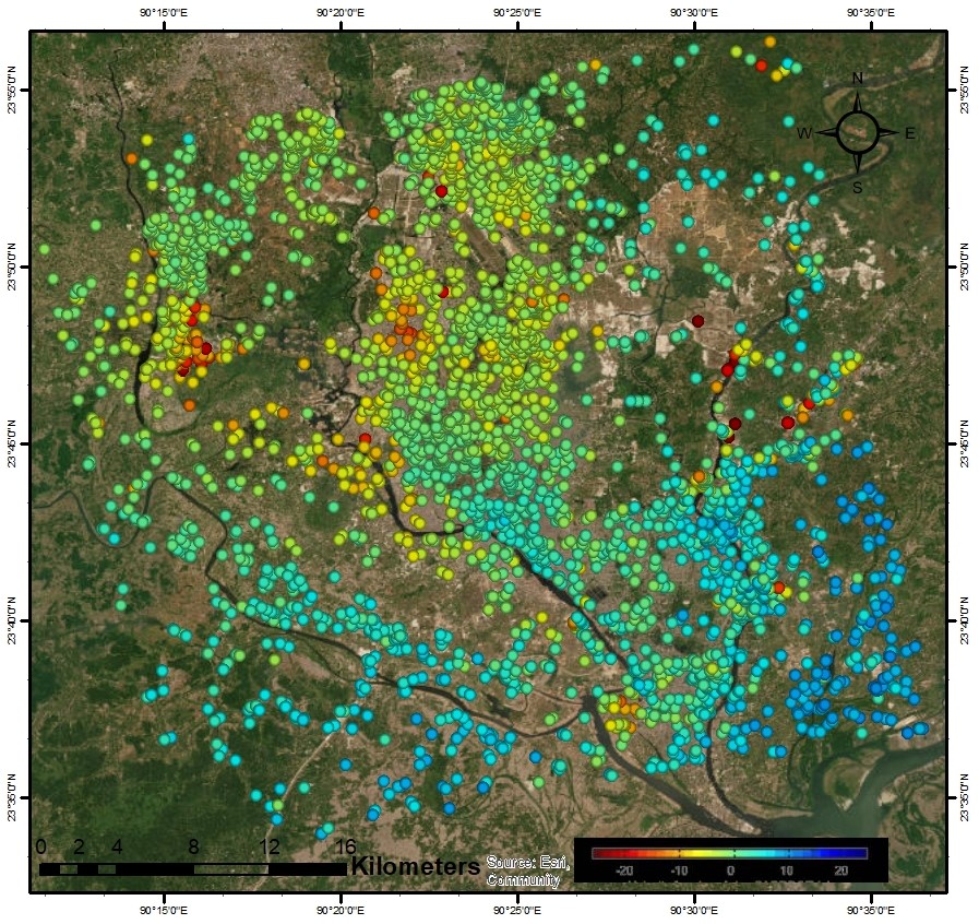
The current study was conducted with the objective of exploring the land subsidence induced by the increasing rapid urbanization and groundwater over exploitation in the city and its environs. The analyses involve utilizations of Differential Interferometric Synthetic Aperture RADAR (DInSAR) and Persistent Sactterer Interferometry (PS InSAR) methodology, which are useful for reconnaissance and precise demarcation of subsiding areas with the rates of subsidence respectively. Measurements of groundwater levels were obtained for the same period, facilitating the relationship between the depletion of groundwater and land subsidence.
The results clearly demonstrate a significant decrease in the groundwater table in specific regions of the capital city, particularly in areas undergoing rapid urban development. The subsidence rate differences in Dhaka are a direct result of the varying levels of aquifer system compaction due to the depletion of ground water level. The degree of subsidence in a particular area is influenced by the presence of either consolidated Pleistocene sediment or unconsolidated Holocene sediments. Consolidated Pleistocene sediment generally shows low subsidence rates, where there unconsolidated Holocene sediments are present, subsidence rates tend to be comparatively higher.
Some recommendations from the current research work:
- The alarming rate of subsidence in some areas raises concerns about potential future damages to infrastructures.
- Considering the severity of the situation, utilizing surface water could emerge as a more sustainable solution.
- The Aquifer Storage and Recovery method is gaining acceptance worldwide as a ground water-storage technology which may be a good solution.
- Introducing innovative recharge techniques to enhance recharge rates, like rainwater harvesting can effectively replenish groundwater levels.
- The placement of GNSS-GPS stations in key deformation zones, over an extended period to yield precise findings.