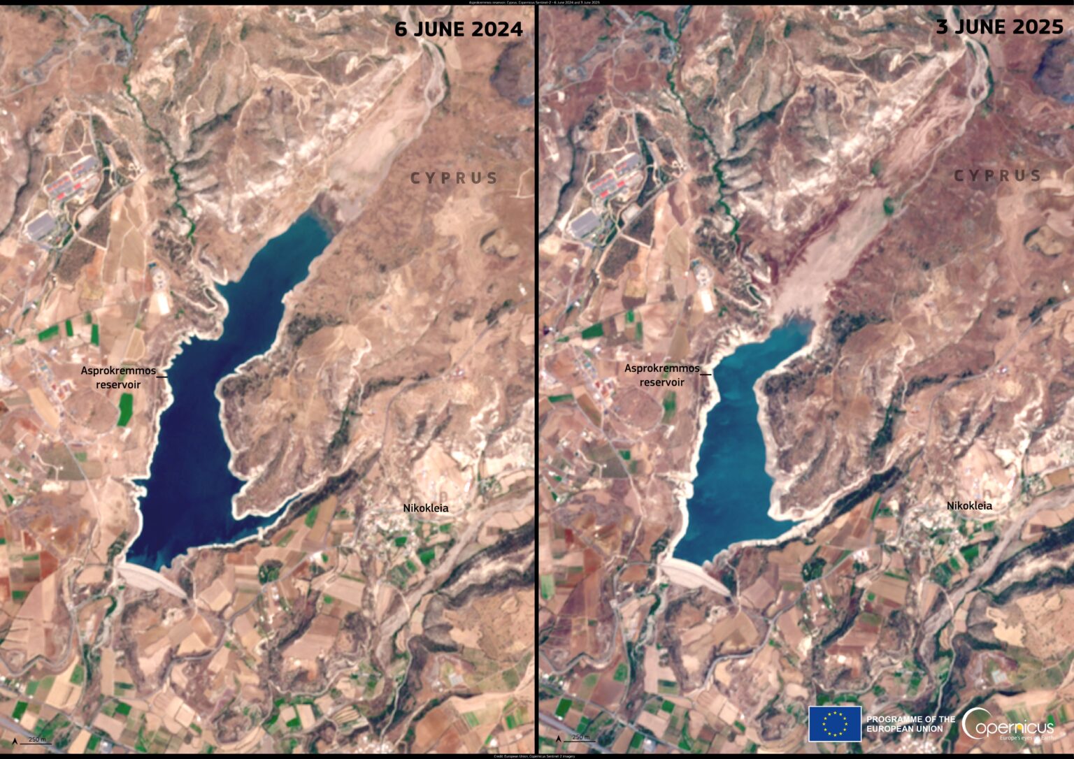
Image of the Week | Archive

These images have been sourced from across EOTEC DevNet community to showcase examples of how Earth Observations are used to inspire and educate the public, as well as assist scientists and decision-makers in their work. If you have a story to tell with satellite imagery – please submit it via this this FORM.

August 28, 2024

Iron-rich sediment colors the red-orange waters of the Betsiboka River Delta in Madagascar in this image taken by an astronaut on the International Space Station…

Fires in Mexico State
August 9, 2024

2024 dry season in Mexico State brought about an intense forest fire on the volcano slopes. Though most forest fires are started by human activities, climate conditions make Mexico State more prone to fires spreading.

July 22, 2024

The EO data, such as Multi-Temporal InSAR Methodology is being used for reconnaissance and precise demarcation of subsiding areas. The results clearly demonstrate a significant decrease in the groundwater table in specific regions of the capital city, particularly in areas undergoing rapid urban development.

June 24, 2024

A critical water source for the Chile’s Coquimbo region, Cogotí Reservoir has significantly diminished due to a severe drought, affecting agriculture and mining. Sentinel-2 satellite imagery reveals drastic changes in water levels between 2023 and 2024, highlighting the urgency of water management.

June 11, 2024

Sentinel-2 images clearly demonstrate how Lacantún River in southeast Mexico changed course between 2019 and 2023. In December 2020, the Lacantún River cut through a meander neck, forming an oxbow lake. The western part of the image shows rainforest and wetland cover, while the eastern part shows remaining patches of rainforest, crops and cultivated grasslands.

May 29, 2024

Dubai was affected by floods during second week of April, 2024 due to the heavy torrential rains. The UAE’s National Center for Meteorology reported that eastern parts of the country measured up to 250 millimeters of rain in less than 24 hours. This extreme amount of precipitation led to submergence of roads, vehicles and disruption of flights. Images acquired from ESA’s Copernicus Sentinel-2 show the pre and post flooding changes in part of Al Taweelah, Abu Dhabi, UAE.

May 7, 2024

On October 14, 2023, the Moon aligned with the Sun and Earth to produce an annular solar eclipse. The spectacle bathed millions of Americans in a lunar shadow as the Moon blocked the Sun’s rays. The above image was acquired during the eclipse by NASA’s Earth Polychromatic Imaging Camera imager aboard the Deep Space Climate Observatory, a joint NASA, NOAA, and U.S. Air Force satellite.

April 10, 2024

What looks like highways going through a metropolitan area are actually a series of glaciers carving their way through the Karakoram mountain range north of the Himalayas. This photograph was taken from the International Space Station as it orbited 263 miles above.